Publications

If you find OpenGeoSys useful for your research please cite us!

Cite the software

Publications

The relevance of two-phase flow in the thermo-hydro-mechanical evolution of clay formations exposed to high temperatures by heat-emitting waste
Jörg Buchwald et al. · 2025 · Applied Thermal Engineering

The relevance of two-phase flow in the thermo-hydro-mechanical evolution of clay formations exposed to high temperatures by heat-emitting waste

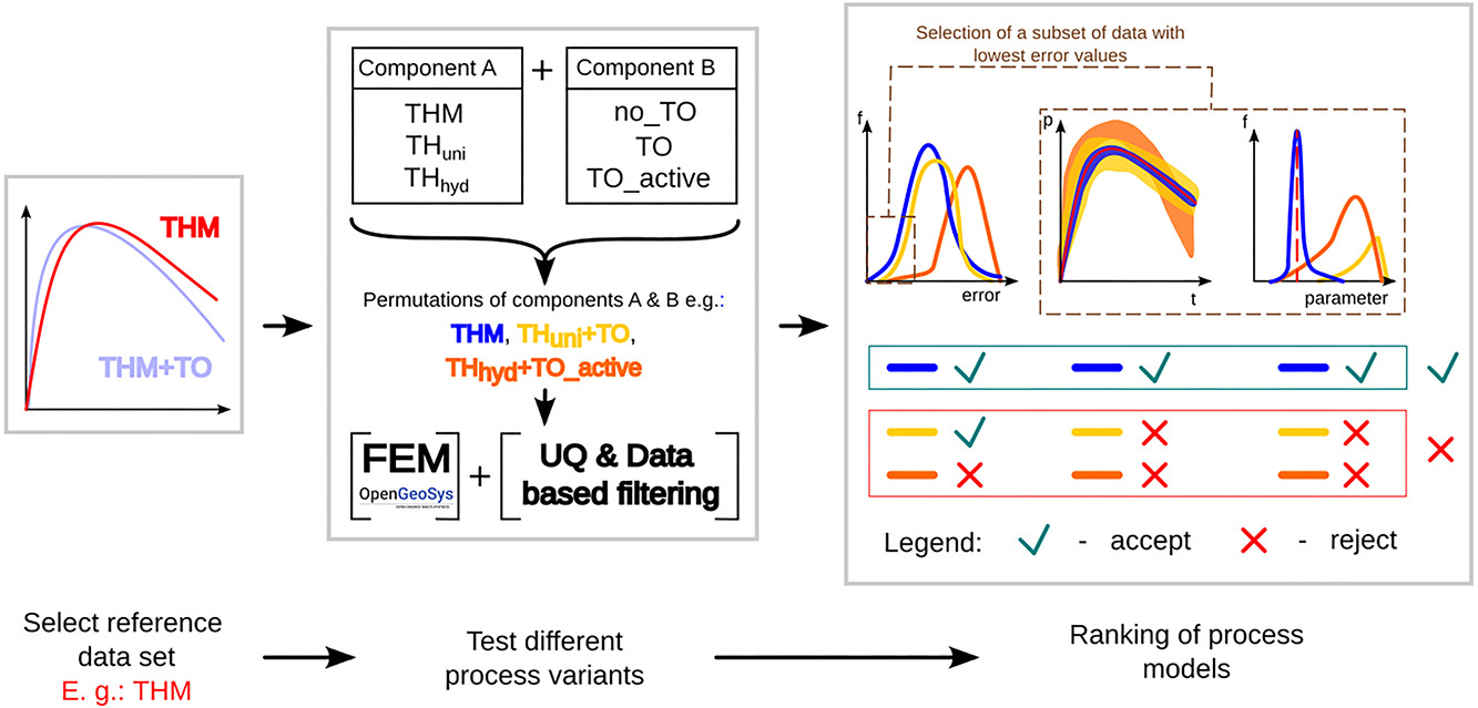
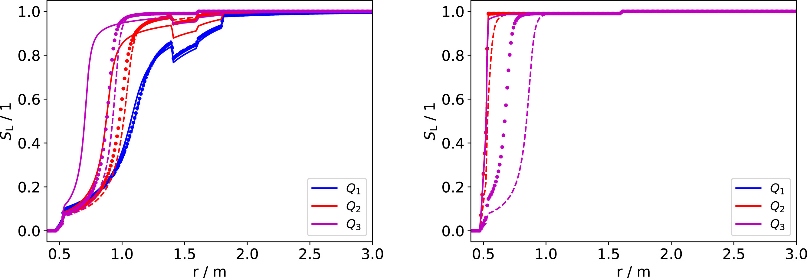
We compare two-phase flow and Richards flow implementations in OpenGeoSys-6 to model the thermo-hydro-mechanical evolution of heat-emitting waste in clay stone formations. Our quasi-1D example is based on the material sequence and domain properties observed in the FE experiment at the Mt. Terri underground research lab in Switzerland. We examine the validity of the Richards assumption by comparing a thermo-hydro-mechanically (THM) coupled Richards model against two THM-coupled two-phase flow-based models, one where the gas pressure is constrained to atmospheric pressure, and one unconstrained model. The model comparison was conducted with saturation-dependent permeability models at temperatures up to ≈200 °C. Additionally, we consider the impact of two different vapor diffusion models, a gas pressure–independent empirical relationship versus the original De Vries model, which becomes relevant if gas pressure buildup is significant. Our results show excellent agreement between the two models for maximum temperatures around 100∘. Even at higher temperatures, above 150 °C, we observe good agreement, which improves significantly with increasing distance from the heater. Even for the highest heat power where both approaches differ significantly in the high-temperature regions, acceptable agreement can be reached outside those regions, i.e. a couple of tens of centimeters away from the heater, but still in the bentonite barrier domain. This work builds confidence in the use of Richards-based approaches for modeling of the THM processes in nuclear waste repository, and contributes to a knowledge-driven model selection in the context of safety-relevant radioactive waste management.

Is more always better? Study on uncertainties introduced by decision-making process of model design — A case study with thermo-osmosis
Feliks K. Kiszkurno et al. · 2025 · International Journal of Rock Mechanics and Mining Sciences

Is more always better? Study on uncertainties introduced by decision-making process of model design — A case study with thermo-osmosis

Proper understanding and handling of uncertainties is critical for the development of safe and reliable facilities for long-term storage of nuclear waste. To prove their safety, numerical simulations are commonly used. They are based on models including physical processes, constitutive assumptions, material parameters, etc. Numerical simulations only approximate the observed reality. Among sources for this mismatch between observations and simulation results are uncertainties in selecting a correct model of the physical processes taking place in the subsurface and uncertainties in parameter values. The impact they can have on the results of the numerical simulations and conclusions drawn from them can be significant and needs to be explored to improve the trust in demonstrations of safety derived from models and numerical simulations. In this study, this will be done by a joint investigation of uncertainties originating from process model selection and parameter calibration. Existing literature suggests a potentially significant impact of thermo-osmosis (TO) on pore pressure evolution as a result of thermal gradients in clay rocks around nuclear waste canisters. In this study, different process models will be confronted with the common belief that more complex models (with more degrees of freedom) will always yield a better match with data. In this perspective, it could be argued that expanding the physical process with TO can be abused for parameter tweaking, leading to overfitting the observed data independent of physical adequacy. To disprove this, uncertainty quantification and sensitivity analysis methods will be applied to test the impact of multiple combinations of assumptions about physical process, relevance of TO and model parameter values to show that it may not necessarily be the most complex model that will represent the observed data best in a plausible manner.

Combining FEFLOW and OpenGeoSys for interoperable workflows
J Heinze et al. · 2025 · Environ Earth Sci

Combining FEFLOW and OpenGeoSys for interoperable workflows

In this paper, we present a Python-based software package that enables the conversion of numerical models from FEFLOW, a commercial groundwater flow, mass and heat transport modelling software, to OpenGeoSys, an open-source software for the simulation of thermo-hydro-mechanical-chemical (THMC) processes in porous and fractured media. This converter enhances interoperability in complex workflows for environmental geotechnics, as multiple software packages are now available for use at different stages of the workflow, thus combining their individual capabilities. We verify the software's correct implementation with various test cases that cover the converter's entire feature set: different physical processes, various boundary conditions, and source terms. The conversion software permits the modification of FEFLOW models post-conversion, which we demonstrate with a real-world example. The converter offers flexibility that extends beyond the modelling approaches in FEFLOW by allowing the use of OGS features. Thereby, it is possible to combine the advantages of FEFLOW, such as the model setup capabilities, with simulations of processes that only OGS supports. The presented software enables users to convert FEFLOW models to widely used open formats such as VTK and XML, fostering collaboration in research and application projects. Furthermore, using an open-source code like OpenGeoSys for simulations enhances the transparency. Geological models of porous and fractured media in open-source formats facilitate the transfer of data and knowledge within large research initiatives, particularly in complex domains such as nuclear waste management.

VR-EX – An Immersive Virtual Reality Serious Game for Science Communication about the ERT Measurements in Mont Terri, Switzerland
N Graebling et al. · 2024 · Environ Earth Sci

VR-EX – An Immersive Virtual Reality Serious Game for Science Communication about the ERT Measurements in Mont Terri, Switzerland

This paper presents the design, implementation, and evaluation of VR-EX, a combination of a virtual field trip and a serious game in immersive virtual reality. The application’s purpose is the communication of research conducted in the Mont Terri underground research laboratory in Switzerland. VR-EX enables users to actively attend electrical resistivity tomography measurements within a geological experiment, from planning to execution to analysis of the results, and in this way imple- ments an active and playful learning approach. The work conducted in underground research laboratories has a high relevance for society as it contributes to research on the final disposal of nuclear waste. Therefore, the active communication of research methodology and results is crucial to increase understanding of scientific processes and boost interest. VR-EX was evaluated in a user study with 35 participants to measure its overall quality and its effectiveness of the knowledge transfer. Taking the evaluation’s qualitative results into account, the application was improved in an iterative process. Overall, the results prove the good quality of the application and its high effectiveness in terms of knowledge transfer. The reported high engagement, joy, and immersion indicate the benefits of employing immersive virtual reality for vivid science communication.

OpenWorkFlow—Development of an open-source synthesis-platform for safety investigations in the site selection process
Christoph Lehmann et al. · 2024 · Grundwasser

OpenWorkFlow—Development of an open-source synthesis-platform for safety investigations in the site selection process

The identification of appropriate locations for secure nuclear waste disposal, a crucial aspect of Germany's nuclear phase-out strategy (StandAG 2017), remains a significant scientific, technical, and political challenge worldwide. The selection and safety assessment of sites demand extensive applications of numerical methods. The OpenWorkFlow project, initiated by Bundesgesellschaft für Endlagerung (BGE), develops a new, open synthesis platform to virtualise repository systems. The simulation platform will evaluate far-field and near-field processes, supporting the site selection process first and the geotechnical design of repository systems later on. The project's development philosophy adheres to the principles of continuity and innovation. Through continuous scientific development, the OpenWorkFlow platform will remain at the forefront of science and technology. Furthermore, as a digital platform, OpenWorkFlow employs up-to-date IT methods and constantly evolving software concepts. As its name suggests, OpenWorkFlow (OWF) is an open platform, developed on the basis of FAIR principles as an open-source project, inviting community participation.

Design-of-Experiment (DoE) based history matching for probabilistic integrity analysis—A case study of the FE-experiment at Mont Terri
J. Buchwald, O. Kolditz, T. Nagel · 2024 · Reliability Engineering & System Safety

Design-of-Experiment (DoE) based history matching for probabilistic integrity analysis—A case study of the FE-experiment at Mont Terri

We present an application of design-of-experiment (DoE) based history matching as an approach to reduce and investigate parameter uncertainties in finite-element models for repositories of high-level radioactive waste. We combine experimental data from the FE-experiment at the Mont Terri underground research laboratory in Switzerland with thermo-hydro-mechanical modeling using the open-source package OpenGeoSys. Uncertainties were reduced by an initial parameter screening to find heavy hitters and an experiment-matching procedure using Monte-Carlo sampling on a Gaussian proxy model to fit the error between modeling response and the experiment. Furthermore, we performed a global sensitivity analysis based on the proxy model, demonstrating the spatial impact of parameter sensitivities. Very good agreement between the experimental data and the model was found for the temperature response, whereas the pressure match hints at a significant remaining gap in the physical models and/or structure. This gap could not be filled within the scope of our contribution and needs further investigation.

Virtual Reality and Computational Efficiency
K Rink et al. · 2023 · Springer, Cham

Virtual Reality and Computational Efficiency

In this chapter we briefly describe information methods and technologies support- ing geotechnical systems analyses, i.e. using virtual reality methods for data and model integration (Sect. 5.1) and improving computational efficiency by using high- performance-computing techniques (Sect. 5.2). The generalised approach of the developed visualisation methodology makes it possible to integrate a variety of data formats into 3D scenes and to create studies for a wide range of application fields1 For example, a prototype for an experiment information system was developed for the rock laboratory in Mont Terri operated by the Federal Office of Topography surveys Switzerland (swisstopo) (Bossart et al. 2017; Jaeggi et al. 2017). This prototype combines a representation of the complex geometry of the Swiss Jura mountains with tunnel system and boreholes of the rock laboratory with a series of results of coupled numerical simulations for the planning and validation of long-time experiments, some of which are designed to run over several decades. Due to the resolution, runtime and complexity of the simulations, the previously described methods for data reduction are essential for the visualisation of the results (Fig. 5.3). Figure 5.1 depicts a map of the URL Mont Terri including local labels for the experiments which have been integrated into the Mont Terri visualization study. The development was carried out in close cooperation with swisstopo as well as the expert scientists who are in charge of the experiments. The visualisation of geotechnical processes requires three-dimensional represen- tation options for coupled field problems as well as validation in the context of corresponding measurement results, therefore, in the following we discuss aspects of data and model integration into a VR framework.

Digitalisation for nuclear waste management: predisposal and disposal
O Kolditz et al. · 2023 · Environ Earth Sci

Digitalisation for nuclear waste management: predisposal and disposal

Data science (digitalisation and artificial intelligence) became more than an important facilitator for many domains in funda- mental and applied sciences as well as industry and is disrupting the way of research already to a large extent. Originally, data sciences were viewed to be well-suited, especially, for data-intensive applications such as image processing, pattern recogni- tion, etc. In the recent past, particularly, data-driven and physics-inspired machine learning methods have been developed to an extent that they accelerate numerical simulations and became directly usable for applications related to the nuclear waste management cycle. In addition to process-based approaches for creating surrogate models, other disciplines such as virtual reality methods and high-performance computing are leveraging the potential of data sciences more and more. The present challenge is utilising the best models, input data and monitoring information to integrate multi-chemical-physical, coupled processes, multi-scale and probabilistic simulations in Digital Twins (DTw) able to mirror or predict the performance of its corresponding physical twins. Therefore, the main target of the Topical Collection is exploring how the development of DTw can benefit the development of safe, efficient solutions for the pre-disposal and disposal of radioactive waste. A particular challenge for DTw in radioactive waste management is the combination of concepts from geological modelling and under- ground construction which will be addressed by linking structural and multi-physics/chemistry process models to building or tunnel information models. As for technical systems, engineered structures a variety of DTw approaches already exist, the development of DTw concepts for geological systems poses a particular challenge when taking the complexities (structures and processes) and uncertainties at extremely varying time and spatial scales of subsurface environments into account.

Prototype of a Virtual Experiment Information System for the Mont Terri Underground Research Laboratory
N Graebling et al. · 2022 · Front Earth Sci

Prototype of a Virtual Experiment Information System for the Mont Terri Underground Research Laboratory

Underground Research Laboratories (URLs) allow geoscientific in-situ experiments at large scale. At the Mont Terri URL in Switzerland, international research groups conduct numerous experiments in parallel. The measured and simulated data as well as research results obtained from them are highly relevant as they improve the general understanding of geological processes, for example in the context of radioactive waste disposal. Unfortunately, the data obtained at the test site is often only available to researchers who are directly involved in a particular experiment. Furthermore, typical visualisation techniques of such data by domain scientists often lack spatial context and accessing and exploring the data requires prior technical knowledge and a high level of effort. We created a digital replica of the Mont Terri URL and thereby implemented a prototype of a Virtual Experiment Information System that integrates highly heterogeneous data from several different sources. It allows accessing and exploring the relevant data embedded in its spatial context without much prior technical knowledge. Both, simulation results and observation data are displayed within the same system. The 4D visualisation approach focuses on three exemplary experiments conducted at Mont Terri and is easily transferable to other experiments or even other URLs. The Unity Game Engine has been used to develop the prototype. This allowed to build the application for various output devices like desktop computers or Virtual Reality hardware without much additional effort. The implemented system reduces the technical effort required to access and explore highly relevant research data and lowers the cognitive effort usually needed to gain insights from measurements, simulation models and context data. Moreover, it promotes exchange among research groups by enabling interactive visualisations embedded in the URL’s spatial context. In addition, a future use of the system for the communication of scientific methods and results to stakeholders or the general public is plausible.

Multi-disciplinary investigation of the hydraulic-mechanically driven convergence behavior: CD-A twin niches in the Mont Terri Rock Laboratory during the first year
G Ziefle et al. · 2022 · Geomechanics for Energy and the Environment

Multi-disciplinary investigation of the hydraulic-mechanically driven convergence behavior: CD-A twin niches in the Mont Terri Rock Laboratory during the first year

To enable safe geological storage of high-level radioactive waste, a comprehensive understanding of the overall system must include relevant physical processes, geological and geotechnical boundary conditions. In the Mont Terri Rock Laboratory (Switzerland) the Cyclic Deformation (CD-A) experiment has been established with the excavation of the two twin niches in the year 2019. To study the impact of the different climatic conditions on the hydraulic and mechanical processes in the claystone, an extensive investigation program has been carried out. As part of the CD-A experiment, we present here a multidisciplinary interpretation including geological characterisation, geodetic and geotechnical measurements, numerical modelling and visualisation techniques. The period under consideration runs between September 2019 and March 2021. Geological mappings illustrate different zones of tectonically induced faulted rock in the sandy facies of the Opalinus Clay and laserscans conducted at regular intervals show small convergence of the niches. While the deformation around the open niche tends to continue, extensometer measurements around the closed twin indicate a reduced deformation after the first months. First coupled hydraulic–mechanical simulations demonstrate that the numerical approach is capable of reproducing the hydro-mechanical behaviour qualitatively, including the extent of the desaturated zone. The application of state-of-the-art visualisation techniques allows simultaneous evaluation and comparison of geological features, measurements and simulation results. This holistic approach – discussed here exemplary for the mechanical effects – provides a valuable basis for the rating of the impact of geologic structures, material heterogeneities, and climatic conditions on the Opalinus Clay. Thus, it can be a valuable component for the safe construction and operation of a repository and for the long term safety assessment.