2023 · Springer, Cham
Virtual Reality and Computational Efficiency
K Rink, N Graebling, L Bilke, J Buchwald, T Fischer, C Lehmann, T Meisel, D Naumov, W Wang, K Yoshioka, O Kolditz
Abstract
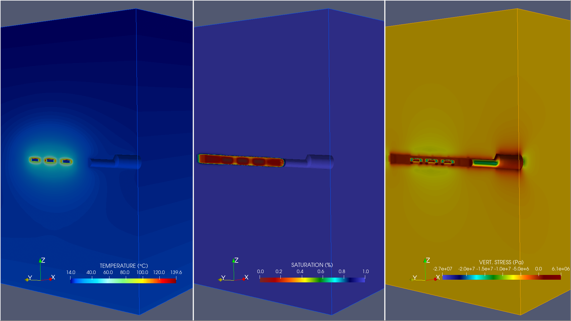
In this chapter we briefly describe information methods and technologies support- ing geotechnical systems analyses, i.e. using virtual reality methods for data and model integration (Sect. 5.1) and improving computational efficiency by using high- performance-computing techniques (Sect. 5.2). The generalised approach of the developed visualisation methodology makes it possible to integrate a variety of data formats into 3D scenes and to create studies for a wide range of application fields1 For example, a prototype for an experiment information system was developed for the rock laboratory in Mont Terri operated by the Federal Office of Topography surveys Switzerland (swisstopo) (Bossart et al. 2017; Jaeggi et al. 2017). This prototype combines a representation of the complex geometry of the Swiss Jura mountains with tunnel system and boreholes of the rock laboratory with a series of results of coupled numerical simulations for the planning and validation of long-time experiments, some of which are designed to run over several decades. Due to the resolution, runtime and complexity of the simulations, the previously described methods for data reduction are essential for the visualisation of the results (Fig. 5.3). Figure 5.1 depicts a map of the URL Mont Terri including local labels for the experiments which have been integrated into the Mont Terri visualization study. The development was carried out in close cooperation with swisstopo as well as the expert scientists who are in charge of the experiments. The visualisation of geotechnical processes requires three-dimensional represen- tation options for coupled field problems as well as validation in the context of corresponding measurement results, therefore, in the following we discuss aspects of data and model integration into a VR framework.
Authors
K Rink, N Graebling, L Bilke, J Buchwald, T Fischer, C Lehmann, T Meisel, D Naumov, W Wang, K Yoshioka, O Kolditz
Details
- Year
- 2023
- Publisher
- Springer, Cham
- Citation key
Rink2023
@incollection{Rink2023,
 abstract = {In this chapter we briefly describe information methods and technologies support- ing geotechnical systems analyses, i.e. using virtual reality methods for data and model integration (Sect. 5.1) and improving computational efficiency by using high- performance-computing techniques (Sect. 5.2). The generalised approach of the developed visualisation methodology makes it possible to integrate a variety of data formats into 3D scenes and to create studies for a wide range of application fields1 For example, a prototype for an experiment information system was developed for the rock laboratory in Mont Terri operated by the Federal Office of Topography surveys Switzerland (swisstopo) (Bossart et al. 2017; Jaeggi et al. 2017). This prototype combines a representation of the complex geometry of the Swiss Jura mountains with tunnel system and boreholes of the rock laboratory with a series of results of coupled numerical simulations for the planning and validation of long-time experiments, some of which are designed to run over several decades. Due to the resolution, runtime and complexity of the simulations, the previously described methods for data reduction are essential for the visualisation of the results (Fig. 5.3). Figure 5.1 depicts a map of the URL Mont Terri including local labels for the experiments which have been integrated into the Mont Terri visualization study. The development was carried out in close cooperation with swisstopo as well as the expert scientists who are in charge of the experiments. The visualisation of geotechnical processes requires three-dimensional represen- tation options for coupled field problems as well as validation in the context of corresponding measurement results, therefore, in the following we discuss aspects of data and model integration into a VR framework.},
 author = {K Rink and N Graebling and L Bilke and J Buchwald and T Fischer and C Lehmann and T Meisel and D Naumov and W Wang and K Yoshioka and O Kolditz},
 booktitle = {GeomInt—Discontinuities in Geosystems From Lab to Field Scale},
 doi = {10.1007/978-3-031-26493-1_5},
 howpublished = {r̆lhttps://link.springer.com/chapter/10.1007/978-3-031-26493-1_5},
 pages = {77–89},
 publisher = {Springer, Cham},
 series = {SpringerBriefs in Earth System Sciences},
 title = {Virtual Reality and Computational Efficiency},
 year = {2023}
}