OpenGeoSys

Open-source multi-physics

OpenGeoSys (OGS) is a scientific open source project for the development of numerical methods for the simulation of thermo-hydro-mechanical-chemical (THMC) processes in porous and fractured media. Current version is OpenGeoSys-6 which is documented on this page. For information about OpenGeoSys-5, see its dedicated section. OGS has been successfully applied in the fields of regional, contaminant and coastal hydrology, fundamental and geothermal energy systems, geotechnical engineering, energy storage, CO2 sequestration/storage and nuclear waste management and disposal.

Announcements

Recent OpenGeoSys publications.

OpenGeoSys
Environ Earth Sci

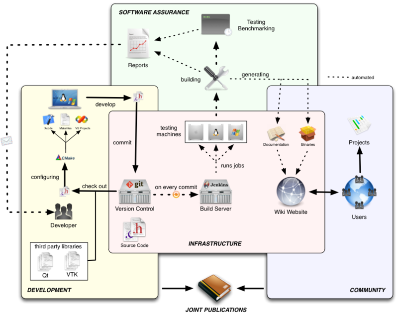
Combining FEFLOW and OpenGeoSys for interoperable workflows

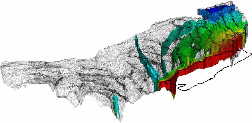
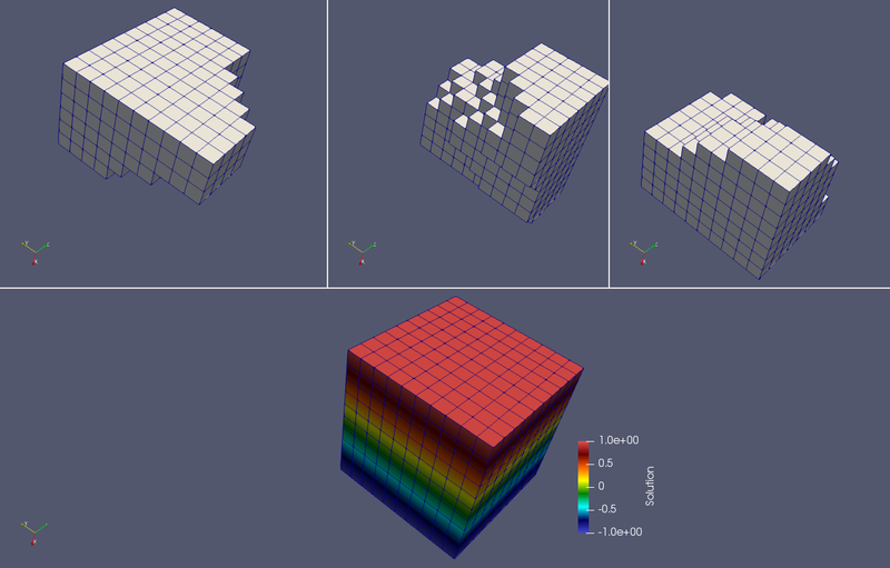
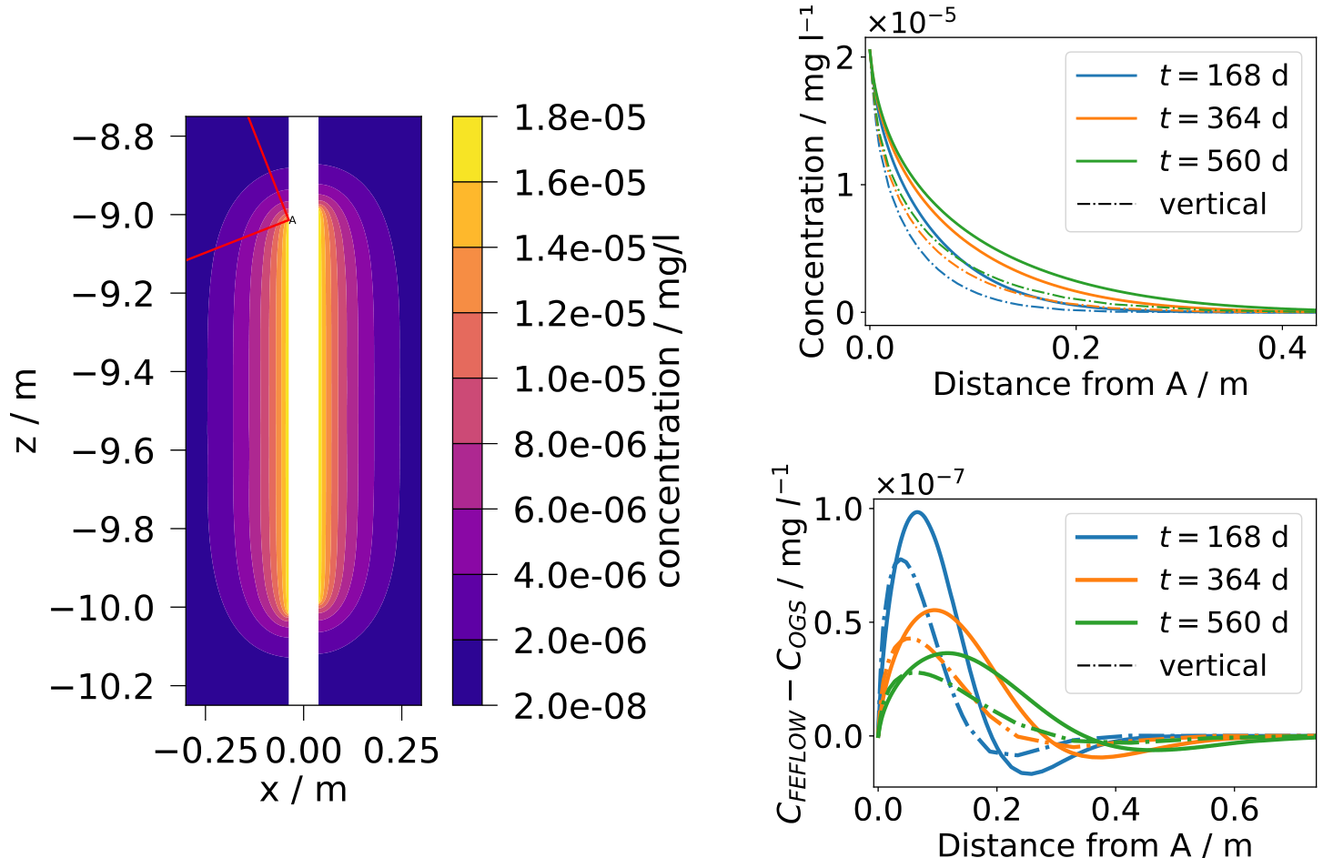
In this paper, we present a Python-based software package that enables the conversion of numerical models from FEFLOW, a commercial groundwater flow, mass and heat transport modelling software, to OpenGeoSys, an open-source software for the simulation of thermo-hydro-mechanical-chemical (THMC) processes in porous and fractured media. This converter enhances interoperability in complex workflows for environmental geotechnics, as multiple software packages are now available for use at different stages of the workflow, thus combining their individual capabilities. We verify the software's correct implementation with various test cases that cover the converter's entire feature set: different physical processes, various boundary conditions, and source terms. The conversion software permits the modification of FEFLOW models post-conversion, which we demonstrate with a real-world example. The converter offers flexibility that extends beyond the modelling approaches in FEFLOW by allowing the use of OGS features. Thereby, it is possible to combine the advantages of FEFLOW, such as the model setup capabilities, with simulations of processes that only OGS supports. The presented software enables users to convert FEFLOW models to widely used open formats such as VTK and XML, fostering collaboration in research and application projects. Furthermore, using an open-source code like OpenGeoSys for simulations enhances the transparency. Geological models of porous and fractured media in open-source formats facilitate the transfer of data and knowledge within large research initiatives, particularly in complex domains such as nuclear waste management.

OpenGeoSys
International Journal of Rock Mechanics and Mining Sciences

Is more always better? Study on uncertainties introduced by decision-making process of model design — A case study with thermo-osmosis

Proper understanding and handling of uncertainties is critical for the development of safe and reliable facilities for long-term storage of nuclear waste. To prove their safety, numerical simulations are commonly used. They are based on models including physical processes, constitutive assumptions, material parameters, etc. Numerical simulations only approximate the observed reality. Among sources for this mismatch between observations and simulation results are uncertainties in selecting a correct model of the physical processes taking place in the subsurface and uncertainties in parameter values. The impact they can have on the results of the numerical simulations and conclusions drawn from them can be significant and needs to be explored to improve the trust in demonstrations of safety derived from models and numerical simulations. In this study, this will be done by a joint investigation of uncertainties originating from process model selection and parameter calibration. Existing literature suggests a potentially significant impact of thermo-osmosis (TO) on pore pressure evolution as a result of thermal gradients in clay rocks around nuclear waste canisters. In this study, different process models will be confronted with the common belief that more complex models (with more degrees of freedom) will always yield a better match with data. In this perspective, it could be argued that expanding the physical process with TO can be abused for parameter tweaking, leading to overfitting the observed data independent of physical adequacy. To disprove this, uncertainty quantification and sensitivity analysis methods will be applied to test the impact of multiple combinations of assumptions about physical process, relevance of TO and model parameter values to show that it may not necessarily be the most complex model that will represent the observed data best in a plausible manner.

OpenGeoSys
Applied Thermal Engineering

The relevance of two-phase flow in the thermo-hydro-mechanical evolution of clay formations exposed to high temperatures by heat-emitting waste

We compare two-phase flow and Richards flow implementations in OpenGeoSys-6 to model the thermo-hydro-mechanical evolution of heat-emitting waste in clay stone formations. Our quasi-1D example is based on the material sequence and domain properties observed in the FE experiment at the Mt. Terri underground research lab in Switzerland. We examine the validity of the Richards assumption by comparing a thermo-hydro-mechanically (THM) coupled Richards model against two THM-coupled two-phase flow-based models, one where the gas pressure is constrained to atmospheric pressure, and one unconstrained model. The model comparison was conducted with saturation-dependent permeability models at temperatures up to ≈200 °C. Additionally, we consider the impact of two different vapor diffusion models, a gas pressure–independent empirical relationship versus the original De Vries model, which becomes relevant if gas pressure buildup is significant. Our results show excellent agreement between the two models for maximum temperatures around 100∘. Even at higher temperatures, above 150 °C, we observe good agreement, which improves significantly with increasing distance from the heater. Even for the highest heat power where both approaches differ significantly in the high-temperature regions, acceptable agreement can be reached outside those regions, i.e. a couple of tens of centimeters away from the heater, but still in the bentonite barrier domain. This work builds confidence in the use of Richards-based approaches for modeling of the THM processes in nuclear waste repository, and contributes to a knowledge-driven model selection in the context of safety-relevant radioactive waste management.

Features

OpenGeoSys’ adaptable and modular architecture enables a wide variety of use cases and flexible workflows. In the following we highlight some of its most important features.

Comprehensive Pre-Processing Tools

A wide range of helper tools exist to get your model up and running with OpenGeoSys.

Convert your existing data sets into appropriate OGS data formats and structures.

Create meshes approximating geometrically the domain of interest. Analyze mesh quality, cleanup the mesh or adding layers to it.

Parametrize the model with material parameters, boundary conditions and source terms.

Extracted surfaces

Process Coupling

A coupled system of equations can be either solved in a fully coupled way of the monolithic method, or in the sequential manner of the staggered scheme. The monolithic scheme is applied for all coupled processes, while the staggered scheme are available for the coupled processes of thermo-hydraulic, hydro-mechanical, and phase field mechanical problems.
Staggered coupling scheme

Data integration

Integrate and visualize data sets for OpenGeoSys by using the OpenGeoSys Data Explorer. It provides functionality to visually assess the data and see possible artefacts, inconsistencies between data sets or missing information.

Visualize results

By using VTK data formats visualizing simulation result data sets becomes an easy task. The de-facto standard software for scientific visualizations ParaView can be used to explore and analyze complex data in a visual way.

Virtual reality enabled visualization brings your data onto the large screen for intuitive exploration and assessment.

High performance computing

High performance computing (HPC) has became a necessity in the modelling of environmental and geotechnical problems for better characterization of the complexity of geo-systems as well as predicting their evolution in time. Parallel computing is the most efficient method in the high performance computing. In OGS, the parallalization of the finite element (FE) computation is based on the domain decomposition method (DDC).

Decomposed global matrices and vectors are handled by PETSc and the system of linear equations are solved by the performant PETSc solver. PETSc builds upon the Message Passing Interface (MPI) suitable for a wide variety of parallel computing architectures.

Parallelization is implemented for single processes as well problems with coupled processes which are using the same order of element for each process.

Domain decomposition for parallel processing

Transparent development workflows

OpenGeoSys is an open-source project developed by a community of researchers. We try to be open-minded and and make team decisions. We try to help users and developers as best as we can.

We invite you to take part in this journey, shape the future of OpenGeoSys together and happily welcome any contribution.

Dev workflow

Setup a development environment

Learn how to obtain the source code, how to install required other software (e.g. compilers and tools), how to configure the software and how to generate the application binary.

Contribute code

Implement your new feature and let the CI system run sophisticated tests automatically for you incorporating multiple computing platforms, a magnitude of software configurations and a whole array of CPU intensive complex test simulation runs.

Get help from core developers

Once your feature is ready the code review process starts. A helpful core developer checks the proposed change for general acceptance and may give hints for improvement (of e.g. the computational performance or the code structure). Once the iterative feedback loop between you, code reviewer(s) and the automated test system satisfies all aspects the proposed change is merged into the main development line.

Ready to dive in?

Using OpenGeoSys

Start using OpenGeoSys by downloading a prebuilt package.

Developing OpenGeoSys

Getting started developing OpenGeoSys at the Developer Guide.

Become part of the Community

Get in touch with the OpenGeoSys Community via our Discussion forum, GitLab or by email.